Supplementary
notes for Arch reading in Course Packet (Chapters 5, 7,8)
I.
TIME
·Two
types of chronology
oRelative
chronology
oAbsolute
chronology
·Relative
chronology
oStratigraphy
§Sequence
of accumulated layers of human occupation
§Based
on law of superposition
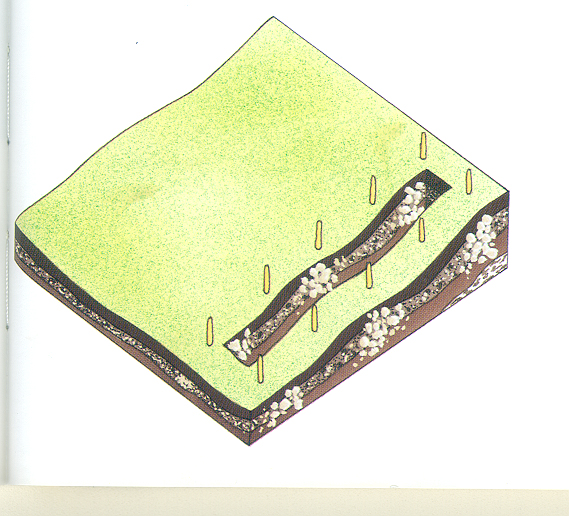
·Diagram
illustrating law (from Arch, p.80)
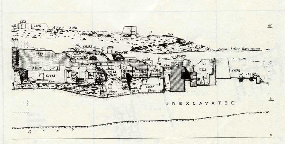
§Stratigraphy
of Karanis
·Village
in Roman Egypt (2nd/3rd century AD)
oLocated
in Fayum
·Excavated
by archaeologists from University of Michigan
·Sectional
plan drawn by archaeologists
oShows
successive occupation levels (stratigraphy)
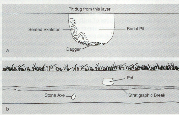
§Exceptions
·Disturbances
among layers by humans or by nature
·Acquisition
& re-use of older artifacts at a particular level
·Landfills
(filling)
oSeriation
§Ordering
of artifacts by stylistic changes
§Assumes
cultural & stylistic change is gradual process
§Used
for artifacts that do not derive from series of excavated levels
§Examples
·Seriation
of pottery bottles according to stylistic features
·Seriation
of wavy-handled pottery from Predynastic Egypt
§Limitations
·There
can be sudden changes in cultural & stylistic traditions
·Cannot
determine direction in which change is taking place
·Absolute
chronology
(chronometric dating)
oHistorical
records & objects of known age
§Coins
§Dated
texts
oRadiocarbon
dating
§Measures
decay of Carbon 14
·Half-life
of Carbon 14 is 5730 years
·Graph
illustrating the relationship between how much Carbon 14 is left in a sample
& how old it is
§Can
only be used on organic materials (e.g. bone, hair, wood, seeds)
oThermoluminescence
§Measures
amount of light energy released by a baked clay object when heated rapidly
§Gives
indication of time elapsed since object was last heated
§Used
especially on pottery
§Significant
margin of error
II.
SPACE
-
Law
of Association
-
Artifact
is contemporary with other objects found in same depositional unit
-
Application
of law (from Arch, p.94)
-
Exceptions
to law
-
Disturbances
to site can mix up artifacts from different layers
III.
ARCHAEOLOGICAL
FIELDWORK
-
Locating
sites
-
Look
for telltale signs of human settlement
-
Archaeological
surveys
-
Walking
around site
-
Traces
of artifacts
-
Soil
& vegetation patterns
-
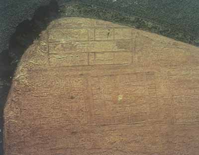
Aerial
photography
-
Satellite
imagery
-
Geographic
Information Systems (GIS)
-
Computer-generated
mapping systems
-
Allow
archaeologists to collect, store, retrieve, & analyze geographical
data
-
Assessing
sites
-
Mapping
of site
-
Produce
accurate plans of site
-
Surface
collection of artifacts
-
Subsurface
investigation
-
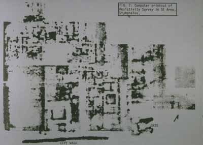
Resistivity
survey meter
-
Helps
to identify underlying structures & other subsurface features at archaeological
site
-
Meter
measures how well ground conducts electrical current
-
High
resistivity
-
Areas
where there are walls or floors of buildings
-
Low
resistivity
-
Produces
outline of underlying structures
-
Excavating
sites
-
Site
testing
-
Test
pit to obtain preliminary information on stratigraphy, etc.
-
Vertical
excavation
-
Digging
limited areas (trenches) for specific information on dating & stratigraphy
-
Horizontal
or open area excavation
-
Layer
by layer exposure of larger areas of site
-
More
extensive than vertical excavations
-
Used
to uncover house plans & settlement layouts
-
Grid
or box excavation
-
Combines
aspects of vertical & horizontal excavation
-
Site
divided into series of squares
-
Squares
were excavated, leaving narrower unexcavated strips between them
-
Provides
record of vertical aspect
-
Unexcavated
strips of land between squares are then removed
-
Provides
record of horizontal aspect
-
Developed
by Mortimer Wheeler in earlier part of 20th century
-
Recording
information from an excavation
(from Arch, p.148)
-
Grid
of squares
-
Horizontal
measurement
-
Vertical
measurement